
The Nukini are part of the group of Pano-speaking peoples who inhabit the Juruá Valley region and are characterized by similar lifestyles and worldviews. They also share the devastating historical experience of expropriation, violence, and exploitation led by the rubber company since the mid-19th century. The Nukini Indigenous Land is now part of one of the most important mosaics of protected areas in Brazil and the world, contiguous to the Serra do Divisor National Park. However, the Nukini are claiming an expansion of their official territory to encompass a portion of the park. Whether this overlap is affected or not, one of their main challenges is to ensure their physical and cultural reproduction while establishing quality relationships with environmentalists and other actors working in the park, whose interests do not always align and have led to various conflicts, making dialogue and joint action to protect the area difficult. Loggers, hunters, and traffickers constantly threaten the area.
Population, Location, and Environment Nukini families are spread along the Timbaúba, Meia Dúzia, República, and Capanawa streams and on the left bank of the Môa River. Most are located within the Nukini Indigenous Land (TI) in the municipality of Mâncio Lima. In 2003, there were approximately 553 people in this TI. Some members of this group can also be found in other cities of the state of Acre, such as Cruzeiro do Sul, Rodrigues Alves, and Rio Branco.
Acre, Juruá, and the Environment The Nukini Indigenous Land is located in Acre, the extreme southwest of the Brazilian Amazon. The state shares international borders with Peru and Bolivia and national borders with the states of Amazonas and Rondônia. The terrain is predominantly made up of sedimentary rocks, forming a regular platform that gently slopes from 300m at the borders to just over 100m at the boundaries with the State of Amazonas. In the far west lies the state’s highest point, where the terrain structure is altered by the presence of the Serra do Divisor, an offshoot of the Peruvian Contamana range, reaching a maximum altitude of 600m.
Acre’s soils support natural vegetation primarily composed of Dense Tropical forests and Open Tropical forests, known for their floristic heterogeneity of high economic value. The climate is equatorial, hot and humid, with high temperatures, high rainfall rates, and high relative humidity. Acre’s hydrography consists of the Juruá and Purus basins, right tributaries of the Solimões River.
The Juruá river basin covers a broad area of 250,000 km². The total length of the Juruá River is 3,280 km, with a drop of 410m. It originates in Peru at an altitude of 453m named Paxiúba, later joining with the Salambô and from there, it is called Juruá. It crosses the northwest part of the state of Acre from South to North, then enters the state of Amazonas and flows into the Solimões River.
The Juruá River has nine main right tributaries: Breu, Caipora, São João, Acuriá, Tejo, Grajaú, Natal, Humaitá, and Valparaíso. And another nine important left tributaries: Amônea, Aparição, São Luiz, Paratati, Rio das Minas, Ouro Preto, Juruá-Mirim, Paraná dos Mouras, and Môa. The Nukini TI is located on the left bank of the upper Môa River.
This TI is included in a “mosaic” of 25 federal lands in the upper Juruá that make up a large region of socio-environmental relevance for indigenous and regional populations, attracting national and international interests. Among the federal lands, there is a National Park, three Extractive Reserves, and 21 Indigenous Lands [data from 2005].
The biodiversity values attributed to the Serra do Divisor National Park (PNSD) are among the highest found in the Brazilian Amazon. This environmental diversity has been used and conserved for centuries by the population residing in this vast region, including the Nukini, whose lands contain much of this biodiversity.”
Name and Language The people currently self-named Nukini belong to the Pano linguistic family. In the past, they might have had another self-denomination. In some historiographic texts, the Nukini are also referred to by the terms Inucuini, Nucuiny, Nukuini, Nucuini, Inocú-inins, and Remo.
Due to contact with agents from the rubber expansion frontier, there are currently few Nukini speakers of their native language. Possibly, having been historically ridiculed and discriminated against for speaking the language, these people stopped passing it on to their descendants, leading to a younger generation educated only in Portuguese.
Speakers of the Pano linguistic family can be found in Peru, Bolivia, and Brazil. In the latter country, Pano indigenous societies are located in the south and west of the state of Acre, extending eastwards to the western part of Rondônia and, heading north, penetrating the state of Amazonas, between the Juruá and Javari rivers.
History References to the Nukini are found in various texts and documents related to the Indians located in the Serra do Divisor region, which is a branch of the Serra da Contamana. As mentioned earlier, these references use several terms, including variations of the designation Nukini and Remo. Regarding the latter term, there is considerable information about Remo in historiography. According to Coutinho, it seems that the Nukini are one of the surviving factions of the so-called Remo Indians (Coutinho, 2001).
For Oppenheim, Remo was a designation attributed to a people who called themselves Nukini, as evident in the quote below:
According to Braulino de Carvalho, of the Limits Commission, he found some families of Rhemus Indians on the right bank of the Jaquirana River, who called themselves “Nucuinis”. Aren’t the “Nucuinis” from Paraná da República and the high Igarapé Ramon from the same tribe as the Jaquirana Indians? Or is it another tribe found by ancient explorers, called “Rhemus”, now disappeared or absorbed by the current “Nucuinis”?
We should note that when we explored the Tapiche River valley, we found several Indians with tattoos identical to the “Nucuinis” described, and they spoke the “Pano” dialect. They were known as Rhemus who came from Jaquirana, yet they called themselves “Nucuinis”. We can assume they might be two different tribes, “Rhemus” and Nucuinis”.
Given the common practice among Amazon tribes of kidnapping women and children and exterminating men in constant wars between neighbouring tribes, this phenomenon of a weaker tribe’s absorption by a stronger and more numerous neighbour could easily occur in the case of the “Rhemus” and Nucuinis tribes. Either way, it seems certain that a large “Nucuinis” tribe recently occupied the region between the Paraná dos Mouras and the Jaquirana River, and the “Rhemus” designation does not correspond to the known tribes of this region called “Nucuinis” (Oppenheim, 1936: 151).
Assuming the Nukini are the same as the Remo – it’s worth noting that on the ethnohistorical map of Curt Nimuendajú, from 1944, the Nukini and Remo are located in very close regions, being considered two different peoples from the Pano linguistic family – various pieces of information can be indicated from historiographic sources about this people. About their name, Castello Branco states:
Some tribes of this family [Pano] were known by different names than the true ones, deviating from the naua ending, however, these nicknames were given by explorers or rubber tappers, considering some sign, mark, or ornament used by its members, like the Remos, Araras, Black Mouths, Thorns, or adopted by the indigenous to avoid enemies, due to the continuous fights in which they lived (Castello Branco, 1950: 28-29).
As the Nukini might have been called Remo, it also becomes possible to state that, throughout the 19th century, they were located east of the Ucayali, between the Serra de Contamana and the Tamaya river, mainly in the Callaria and Abujao river valleys, besides being close to the Canchahuaya hills. At the beginning of the 20th century, there are mentions of the Remo in the region of the upper Juruá Mirim, upper Jaquirana River, and Tapiche River, a tributary of the lower Ucayali (Coutinho, 2001).
There is a lot of information about the location of the Remo on the border between Brazil and Peru, but only in the early decades of the 20th century are there specific references to the Nukini, located in the upper Môa River. During this period, some Nukini Indians, led by Xáxá-Baca, were taken by the Peruvian D. Francisco Baría, under the pretext of a trip, to Peruvian territory. In that country, they were used as a form of debt payment by the Peruvian to his boss, of the same nationality. The Nukini fled that country and returned to their maloca in the Gilbratar rubber plantation, located in Brazil. According to Máximo Linhares, SPI Inspector, who was in the Môa region in 1911:
On his return, the fearless Xáxá-Baca wanted to be tuchaua of the Inocu-inins, fighting a tremendous tacapi battle with the real leader named Purivavô, known to the civilized as Evaristo, who is also very brave, resulting in the maloca’s division into two factions that remained neighbours (Linhares, 1913).
Besides highlighting the internal conflicts existing at that time among the Nukini, Máximo Linhares also informs that these people resided in the Gibraltar rubber plantation and that the term “inocu-inins” meant “poisonous and fragrant jaguar”. To him, the Nukini were good workers and friends of the “civilized”, with whom they had small trade relations. Linhares also adds that there were about “60 inocu-inins Indians in the upper Môa”. He intended to establish an indigenous nucleus under the SPI administration, aiming at the “civilization” of this group (Linhares, 1913).
Shortly after the SPI inspector made this report, another traveller, Father Tastevin, refers to the Nukini Indians located in the Môa River region. Still, in the first half of the 20th century, the Nukini remained in this region, as can be seen in other travellers’ reports. Oppenheim, for example, refers to them as located on the border with Peru, at the headwaters of the Igarapé Ramón, a tributary of the upper Môa River:
We found a group of about ten families of this tribe, in the border area, near the headwaters of the Igarapé Ramón. On the way, they are called the Nucuinis. They live next to each other in large malocas and cultivate a garden, whose products, mainly manioc and bananas, they exchange with Brazilian extractors for shotguns, machetes, cloth, and other products. They make and sell beautiful vases of ceramic, decorated with incised motifs and painted with black, reddish and yellow dyes. They are enemies of the Marubos and like to tattoo their bodies (Oppenheim, 1936: 149-150).
In 1948, Emygdio Del Mestre, a public servant of the SPI in Cruzeiro do Sul, also located the Nukini in the upper Môa River, during a trip through the Serra do Divisor, especially in the headwaters of the Igarapé Ramón:
The Nukini lived in four malocas, two of which were located on the right bank of the Igarapé Ramón, above its confluence with the Môa River, another on the left bank of the Môa River, just below the mouth of the Igarapé Ramón, and a fourth on the right bank of the Igarapé Preto, a tributary of the Ramón. The largest of these malocas, with about 60 Indians, was located at the mouth of the Igarapé Preto (Del Mestre, 1950: 56).
The available records indicate that the Nukini, after being expelled from the Peruvian territory and returning to Brazil, remained in the upper Môa river region, on the border with Peru, at least until the 1950s. There are no available records, however, that indicate the subsequent location of these Indians.
Throughout the 20th century, despite various government initiatives, the land situation of the Nukini and other indigenous peoples in the Juruá valley remained precarious. According to federal agent Geraldo Pinto, the region had few indigenous lands demarcated, and the rubber plantations dominated, which was due to the rubber cycle’s economic interests.
The explorers’ descriptions, like the few that exist for the Nukini, highlight the fascination with the exotic character of the Indians’ life, especially when they were found in their “wild state”. The interest in making them participants in the “Brazilian civilization” was evident in the reports, since, for the SPI officials, it was essential to civilize the Indians. Still, it was necessary to maintain them in the indigenous territory, away from national society, in reserves, preventing them from becoming a “public danger” (Linhares, 1913).
The idea of “assistance” to the Indians was present in the SPI, highlighting the importance of making them economically productive. State intervention should take place in the area of indigenous health, education, and territorial organization. It was in this context that a strategy for the economic and productive integration of the Nukini into the regional economy of the Acre Valley was outlined.
This process of economic integration, however, took place in an extremely violent way, through forced labour in the rubber plantations. The Nukini Indians, like the vast majority of the indigenous people of the Juruá valley, were subjected to the seringalista system, characterized by the infamous “aviamento”, which tied the indigenous worker to the rubber plantation’s owner, preventing him from leaving the place without paying his supposed debt. The Nukini, in this context, worked for the rubber tappers, producing latex, and for their work, they received products from the rubber plantation’s shop.
The rubber plantation system’s degradation, which began in the 1910s and 1920s, led the Nukini, as well as other indigenous peoples of the Juruá valley, to gradually abandon the seringais, moving to areas further and further away from the region’s urban centres. They sought to escape forced labour and the diseases brought by the “civilized”, as well as to avoid the constant wars they waged against the neighbouring tribes.
The disintegration of the rubber system, with the end of the Amazonian latex monopoly due to the cultivation of rubber trees in Asia, led to a change in the indigenous peoples’ situation. The economic boom brought about by the rubber cycle allowed for a considerable population expansion in the Acre Valley, attracting Brazilians from the Northeast and foreigners, mainly Bolivians and Peruvians, who came in search of work in the rubber plantations.
This population expansion brought about intense territorial conflicts between the different groups interested in the region’s resources, leading to the expulsion of the indigenous populations from their traditional territories. In this context, the Nukini, like the other indigenous peoples of the Juruá valley, were gradually removed from the areas of economic interest, being confined in places further and further away from the urban centres and from the seringais.
The establishment of the Serra do Divisor National Park, in 1989, represented an important milestone in the recognition and demarcation of the indigenous territories of the Juruá Valley, including the Nukini. The park, which encompasses an area of 840,000 hectares, was created to protect the region’s rich biodiversity and the traditional ways of life of its indigenous and riverine populations. The Nukini, as well as other indigenous peoples of the Juruá Valley, have played a fundamental role in the park’s creation and management, participating in its decision-making processes and contributing to the conservation of its natural resources.
However, despite the advances represented by the creation of the park, the Nukini and other indigenous peoples of the Juruá Valley continue to face numerous challenges, mainly related to the increasing pressures on their territories, resulting from the expansion of agricultural frontiers, logging, and other economic activities.
The recognition of their rights, as well as the strengthening of their traditional ways of life and their active participation in decision-making processes, are essential for the sustainable development of the region and for the preservation of its rich cultural and biological diversity.
Recognition Process of the Indigenous Land The administrative demarcation procedure for the Nukini Indigenous Land began with Ordinance No. 160/P, dated 23/03/1977, which established a Working Group to survey and delimit indigenous areas located in the region between the Serra do Divisor or Contamana and the Juruá River. At that time, based on a report by anthropologist Delvair Montagner, the extension of the Indigenous Land was estimated at approximately 23,000 hectares, as stated in the Announcement of 08/02/1979, published in the Official Federal Gazette (DOU) on 26/04/1979.
Later, by Ordinance No. 1619/E, dated 30/01/1984, a group led by anthropologist José Carlos Levinho was assigned to conduct land and field surveys to define the “Indigenous Area.” This ordinance also mandated the same work be done on the Poyanawa, Jaminawa of Igarapé Preto, and Katukina of Campinas lands. The anthropologist’s report proposed an area of approximately 30,900 hectares for the Nukini Indigenous Land.
In 1985, Ordinance No. 1911/E, dated 31/06, ordered the start of demarcation works for the Indigenous Land. This ordinance was extended by another, no. 1958/E, dated 16/10, which in turn was extended by no. 1986/E, dated 02/12 of the same year. The proposed area for demarcation was reviewed by GTI/83, which gave Opinion no. 047, dated 17/12/1985, in favour of approving the delimitation proposal for the “Nukini Indigenous Area.”
Almost six years later, the administrative demarcation of the area was ratified by Decree no. 400, dated 24/12/1991, covering a surface of 27,263.5212 hectares. The following year, the “Nukini Indigenous Area” was registered at the Registry Office of the County of Cruzeiro do Sul. However, after the registration, Ordinance no. 1204, dated 25/11/1993, published in the DOU on 29/11, established a technical group to identify and delimit several “indigenous areas” in the state of Acre, including the “Nukini Indigenous Area of Recreio I”. On that occasion, the Nukini did not claim a revision of the boundaries of their land. Only in 2000 did the Nukini begin to claim a revision of the northern and western limits of their land, overlapping the latter with a part of the Serra do Divisor National Park.
Way of Life According to Philippe Erikson, the Pano “ethnolinguistic” family located in the western Amazon is characterized by its vast territorial, linguistic, and cultural homogeneity, but its internal diversity should not be overlooked.
Due to intense contact with rubber tappers, small farmers, and riverside dwellers in the upper Juruá region, the Nukini adopted many of their customs but cherish their uniqueness, especially regarding their social organization.
The Nukini have a clan organization, and the elders can accurately define the entire patrilineal descent of Nukini families, classifying their members according to the clans they belong to Inubakëvu (“jaguar people”), Panabakëvu (“açaí people”), Itsãbakëvu (“patua people”), or Shãnumbakëvu (“snake people”). Many young Nukini, however, are unaware of which clan they belong to, disregarding such criteria for their marital choices.
In general, Nukini homes house nuclear families. Near a residence, there may be other homes of children who have married and formed another nuclear family. The residence pattern often relates to marriage rules, with the male child living close to his father-in-law. But this rule isn’t always followed, as after marriage, the couple can choose a place far from their families of origin to live.
Nukini residences are generally built with forest resources. Some houses have walls and floors made of paxiubão and roofs covered with palm leaves, especially from Caranaí. Other dwellings are built with sawn board walls and floors, usually from quality woods (amarelinho, bacuri, copaíba, red cedar, laurel, bacuri, and angelim), while posts and beams are made with maçaranduba, muirapiranga, avocado laurel, and pau d’arco. Some houses also have aluminium roofs, mainly used in schools and health posts.
Descent is patrilineal, as seems to occur in most Pano peoples, with defined gender and age labour divisions. Men are primarily responsible for hunting, gathering, and farming activities. Women handle tasks related to the domestic realm, as well as gathering forest products, making handicrafts, and assisting in agriculture.
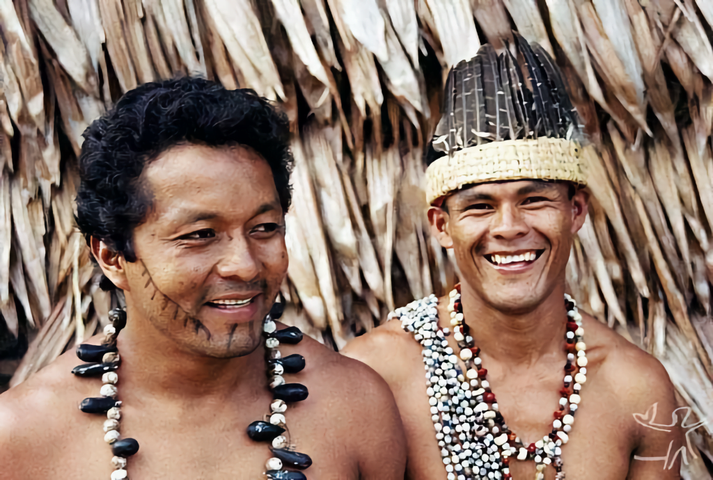
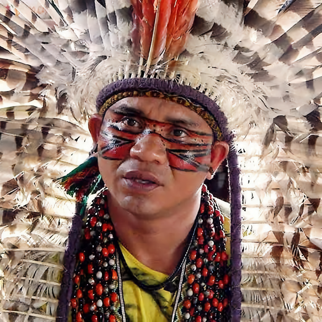
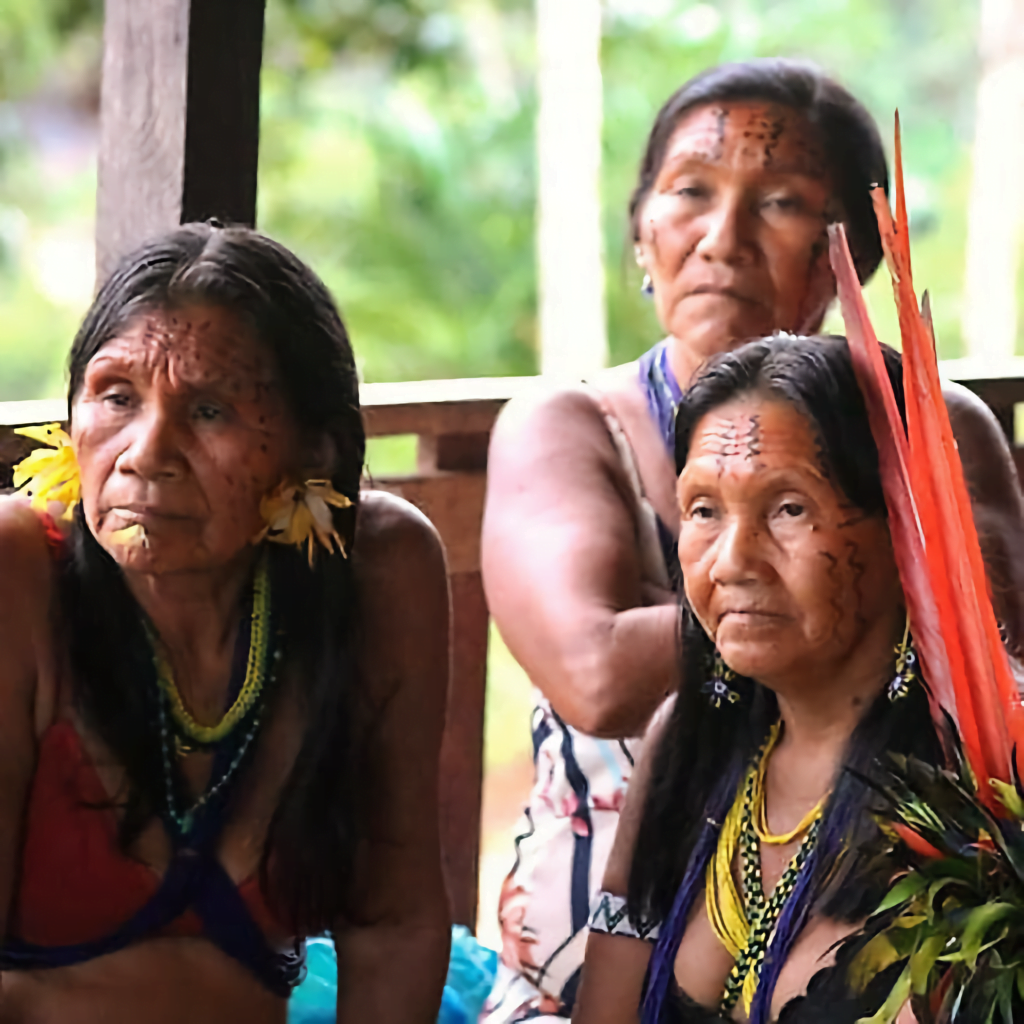
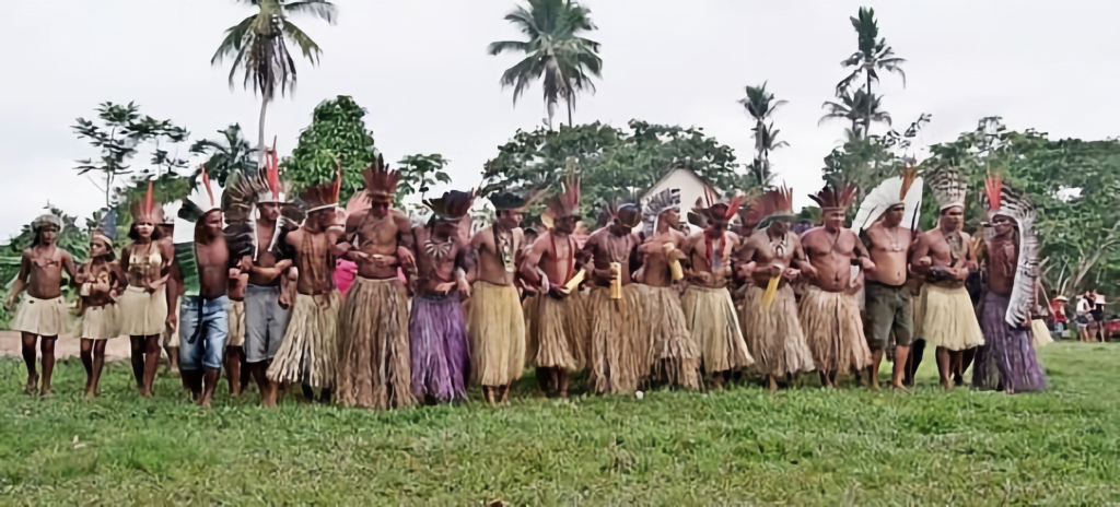
The Nukini also have a rich material culture. They produce various kinds of pottery for domestic use, and basketwork, which includes mats, baskets, and fans. One of their most unique productions is “kené,” a decorative design applied to objects and bodies during ceremonies. Kené has specific patterns for men and women, and its geometric motifs represent animals, spirits, and ancestral beings.
The Nukini maintain a deep connection with nature and the spiritual world, seeking a balance between the two. Through their rituals and practices, they share their stories, memories, and beliefs, ensuring the continuation of their unique cultural identity.
Cloude de Souza Correia
Antropólogo. Doutor pelo PPGAS/UNB. Especialista em Assuntos Indígenas
Sources:
https://pib.socioambiental.org/pt/Povo:Nukini
CASTELLO BRANCO, José Moreira Brandão. “O gentio acreano”. In : Revista do Instituto Histórico e Geográfico Brasileiro. Rio de Janeiro : Imprensa Nacional, Vol. 207, Abril-Junho, 1950. pp. 3-77.
COUTINHO JR., Walter. Relatório de viagem : áreas de ocupação indígena ainda não regularizadas no Acre e sul do Amazonas. Brasília : Funai, 2001.
ERIKSON, Philippe et al. Kirinkobaon kirika (“Gringos’ Books”) : an annotated panoan bibliography. Amerindia, Paris : A.E.A., n. 19, 152 p., supl., 1994.
ERIKSON, Philippe. “Uma singular pluralidade: a etno-história Pano”. In: CUNHA, Manuela Carneiro da (org.). História dos índios no Brasil. São Paulo : Companhia das Letras, FAPESP, SMC, 1992. pp. 239-266.
FUNDAÇÃO DE CULTURA E COMUNICAÇÃO ELIAS MANSOUR; CIMI. Povos do Acre : história indígena da Amazônia Ocidental. Rio Branco : Cimi/FEM, 2002. 58 p.
LINHARES, Máximo. “Os índios do Território do Acre. Impressões de um Auxiliar da Inspetoria do Serviço de Proteção aos Índios e Localização dos Trabalhadores Nacionaes”. In: Jornal do Commércio, 12 de janeiro de 1913.
MENDONÇA, Simone Sussekind de. Nukini. In: GONÇALVES, Marco Antônio Teixeira (Org.). Acre : história e etnologia. Rio de Janeiro : Núcleo de Etnologia Indígena/UFRJ, 1991. p. 271-6.
OPPENHEIM, Victor. Notas ethnographicas sobre os indígenas do alto Juruá (Acre) e Valle do Ucayaly (Perú). Anais da Academia Brasileira de Ciências, vol. 8:145-155, 1936.
TASTEVIN, Constant. “Em Amazonie. Sur lê Moa, aux limites extremes du Brésil et du Perón”. In : Missions catholiques, Tomo XLVI, 1914, pp. 502-504; 514-516; 526-528; 537-539; 550-552 e 559-561.